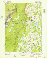
1948 Map of Waymart
USGS Topo · Published 1948About this map
Industrial activity and institutional land use define this 1948 topographic study of the ridge-and-valley landscape between Carbondale and the surrounding plateau. The Lackawanna River corridor serves as a busy transportation hub, hosting the Erie Railroad, the Delaware and Hudson Railroad, and the New York Ontario and Western Railway. These lines support the anthracite-rich valley while navigating the steep climb over the Moosic Mountains. To the east, the terrain transitions into a cluster of smaller settlements and agricultural tracts, including Waymart and South Canaan. Significant local landmarks are carefully noted, such as the Fairview State Hospital and the Russian Monastery, illustrating the diverse social and religious institutions established in this part of Wayne County. Numerous small water bodies like Lake Lodore and Keen Pond dot the eastern plains, while the western heights are managed for water storage at Brownell Reservoir and its associated basins.
Find a feature on this map
44 named features on this map. Tap any name to fly to it.
Don’t see what you’re looking for? This feature index may not catch every label — zoom into the map to look around manually.
Map Details
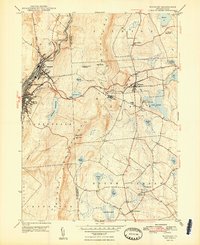
Editions of this 1948 Waymart Map
2 editions found
Other maps of this area

1889 · Scranton
USGS Topo · 1:62,500

1891 · Scranton
USGS Topo · 1:62,500

1892 · Honesdale
USGS Topo · 1:62,500

1892 · Dundaff
USGS Topo · 1:62,500

1893 · Scranton
USGS Topo · 1:62,500

1928 · Ariel
USGS Topo · 1:62,500

1932 · Ariel
USGS Topo · 1:62,500

1943 · Scranton
USGS Topo · 1:125,000

1943 · Honesdale
USGS Topo · 1:125,000

1946 · Olyphant
USGS Topo · 1:24,000