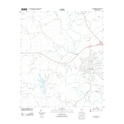
2012 Map of Waynesboro
USGS Topo · Published 2012About this map
The Waynesboro city grid and its surrounding industrial landscape dominate this Wayne County survey. The Chickasawhay River and its major tributaries, including Limestone Creek and Yellow Creek, define the local drainage and topography. This area is heavily marked by the regional energy economy, specifically the Yellow Creek Oil Field in the northwest and the Boyce Oil Field to the northeast. Several historic burial grounds, such as Mozingo Cemetery and Gray Cemetery, are scattered across the rural landscape, offering valuable points of interest for genealogists. To the south, the Waynesboro Municipal Airport and the Wayne Lookout Tower represent modern infrastructure and forest management. The presence of settlements like Woodwards and Boice along the arterial roads illustrates the township's development away from the river banks.
Find a feature on this map
123 named features on this map. Tap any name to fly to it.
Don’t see what you’re looking for? This feature index may not catch every label — zoom into the map to look around manually.
Map Details
Editions of this 2012 Waynesboro Map
This is the sole edition of this map. No revisions or reprints were ever made.
Other maps of this area

1953 · Hattiesburg
USGS Topo · 1:250,000

1958 · Hattiesburg
USGS Topo · 1:250,000

1964 · Denham
USGS Topo · 1:24,000

1964 · Eucutta
USGS Topo · 1:24,000

1964 · Clara
USGS Topo · 1:24,000

1964 · Waynesboro
USGS Topo · 1:24,000

1964 · Whistler
USGS Topo · 1:24,000

1964 · Shubuta
USGS Topo · 1:24,000

1964 · Buckatunna
USGS Topo · 1:24,000

1964 · Matherville
USGS Topo · 1:24,000