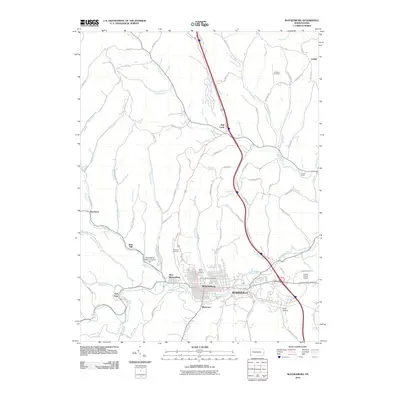
2010 Map of Waynesburg
USGS Topo · Published 2010About this map
Waynesburg serves as the focal point of this southwestern Pennsylvania landscape, situated at the confluence of several vital watercourses including the South Fork Tenmile Creek and Purman Run. The 2010 street grid reveals a dense network of neighborhoods like Blairtown and Morrisville, alongside landmarks such as Carl D Johnson Commons. To the west, the Waynesburg Water Company Dam on Browns Creek illustrates the infrastructure supporting this regional hub. The surrounding terrain is defined by its deep connectivity, with numerous smaller communities such as Sycamore, Castile, and Ruff Creek linked by winding valley roads.
Find a feature on this map
100 named features on this map. Tap any name to fly to it.
Don’t see what you’re looking for? This feature index may not catch every label — zoom into the map to look around manually.
Map Details
Editions of this 2010 Waynesburg Map
This is the sole edition of this map. No revisions or reprints were ever made.
Other maps of this area

1901 · Amity
USGS Topo · 1:62,500

1901 · Waynesburg
USGS Topo · 1:62,500

1904 · Amity
USGS Topo · 1:62,500

1904 · Waynesburg
USGS Topo · 1:62,500

1905 · Rogersville
USGS Topo · 1:62,500

1907 · Claysville
USGS Topo · 1:62,500

1949 · Clarksburg
USGS Topo · 1:250,000

1951 · Canton
USGS Topo · 1:250,000

1953 · Canton
USGS Topo · 1:250,000
1954 · Ellsworth
USGS Topo · 1:24,000