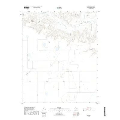
2019 Map of Wayside
USGS Topo · Published 2019About this map
Palo Duro Canyon dominates the northern reaches of this landscape, where the Prairie Dog Town Fork Red River carves through the High Plains. The dramatic descent from the flat ranchland into the canyon system is marked by prominent rim features such as Indian Trail Point, Wilson Point, and the deep recesses of McGehee Hollow. These landforms illustrate the sharp contrast between the level agricultural plateaus and the intricate erosional geology typical of the Texas Panhandle.
Find a feature on this map
25 named features on this map. Tap any name to fly to it.
Don’t see what you’re looking for? This feature index may not catch every label — zoom into the map to look around manually.
Map Details
Editions of this 2019 Wayside Map
This is the sole edition of this map. No revisions or reprints were ever made.
Other maps of this area

1954 · Plainview
USGS Topo · 1:250,000

1956 · Fortress Cliff
USGS Topo · 1:24,000

1958 · Plainview
USGS Topo · 1:250,000

1960 · Wayside
USGS Topo · 1:62,500

1963 · Luttrell Springs
USGS Topo · 1:24,000

1963 · Pleasant Creek
USGS Topo · 1:24,000

1965 · Vigo Park
USGS Topo · 1:24,000

1969 · Jackson Hill
USGS Topo · 1:24,000

1969 · Tule Lake NW
USGS Topo · 1:24,000
1984 · Pony Flats
USGS Topo · 1:24,000