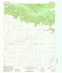
1984 Map of Wayside
USGS Topo · Published 1984About this map
Wayside stands at the transition between the flat High Plains and the dramatic escarpment of the Prairie Dog Town Fork Red River. This 1984 survey reveals an agricultural landscape dotted with numerous wells and cattle-related infrastructure, including a large Feedlot and a Rodeo Ground. The terrain is defined by deep incisions like Cobb Canyon, Happy Canyon, and McGehee Hollow, which drop away from prominent overlooks such as Indian Trail Point and Wilson Point. Local history is marked by a Historical Monument overlooking Old Home Draw, while the presence of a Landing Strip and Gravel Pits reflects the area's mid-century rural utility. The complex drainage network, featuring Antibust Creek and Pleasant Draw, illustrates the erosive power that has shaped this portion of the Texas Panhandle.
Find a feature on this map
20 named features on this map. Tap any name to fly to it.
Don’t see what you’re looking for? This feature index may not catch every label — zoom into the map to look around manually.
Map Details
Editions of this 1984 Wayside Map
This is the sole edition of this map. No revisions or reprints were ever made.
Other maps of this area

1954 · Plainview
USGS Topo · 1:250,000

1956 · Fortress Cliff
USGS Topo · 1:24,000

1958 · Plainview
USGS Topo · 1:250,000

1960 · Wayside
USGS Topo · 1:62,500

1963 · Luttrell Springs
USGS Topo · 1:24,000

1963 · Pleasant Creek
USGS Topo · 1:24,000

1965 · Vigo Park
USGS Topo · 1:24,000

1969 · Jackson Hill
USGS Topo · 1:24,000

1969 · Tule Lake NW
USGS Topo · 1:24,000
1984 · Pony Flats
USGS Topo · 1:24,000