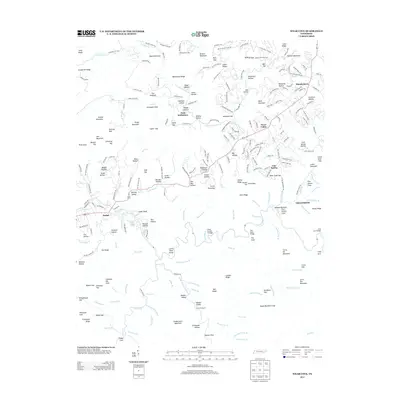
2013 Map of Wear Cove
USGS Topo · Published 2013About this map
Wear Valley and Hatchertown occupy the lowland gaps between the ridges of the Great Smoky Mountains in this 2013 survey. The landscape is defined by its numerous named hollows, such as Rudd Hollow, Walker Hollow, and Dunn Hollow, which characterize the traditional mountain settlement patterns. The Little River and its major tributaries, including the Middle Prong Little River, flow through the southern portion of the quadrangle, where landmarks like The Sinks and the Camp Number 2 Bridge indicate a region shaped by both natural water features and early 21st-century infrastructure. Small communities like Line Spring and Bethel are connected by a network of winding roads like Waldens Creek Rd and Happy Hollow Rd, reflecting a balance between residential growth and the preserved geography of the Greenbrier area. This map provides a detailed view of family-named landmarks like Mitchell Hollow and Bonner Hollow that remain vital for genealogical research in Blount County.
Find a feature on this map
251 named features on this map. Tap any name to fly to it.
Don’t see what you’re looking for? This feature index may not catch every label — zoom into the map to look around manually.
Map Details
Editions of this 2013 Wear Cove Map
This is the sole edition of this map. No revisions or reprints were ever made.
Other maps of this area

1886 · Knoxville
USGS Topo · 1:125,000

1892 · Knoxville
USGS Topo · 1:125,000

1894 · Knoxville
USGS Topo · 1:125,000

1895 · Knoxville
USGS Topo · 1:125,000

1901 · Knoxville
USGS Topo · 1:125,000

1935 · Knoxville
USGS Topo · 1:48,000

1935 · Walden Creek
USGS Topo · 1:24,000

1935 · Wildwood
USGS Topo · 1:24,000

1935 · Sevierville
USGS Topo · 1:48,000
1935 · Pigeon Forge
USGS Topo · 1:24,000