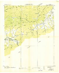
1936 Map of Wear Cove
USGS Topo · Published 1936About this map
Tuckaleechee Cove and Wear Cove dominate this mid-1930s landscape, captured just as the boundary for the Great Smoky Mountains National Park was being established across the southern ridges. The settlement pattern follows the valley floors, with small communities like Townsend and Hatchertown connected by State Hy No 73 and a local Railroad. The map reveals a deeply rooted social geography, evidenced by the numerous small churches and schools serving the coves, including Coker Hill Sch, Wearwood Sch, and Headrick Chapel.
Find a feature on this map
65 named features on this map. Tap any name to fly to it.
Don’t see what you’re looking for? This feature index may not catch every label — zoom into the map to look around manually.
Map Details
Editions of this 1936 Wear Cove Map
This is the sole edition of this map. No revisions or reprints were ever made.
Other maps of this area

1886 · Knoxville
USGS Topo · 1:125,000

1892 · Knoxville
USGS Topo · 1:125,000

1894 · Knoxville
USGS Topo · 1:125,000

1895 · Knoxville
USGS Topo · 1:125,000

1901 · Knoxville
USGS Topo · 1:125,000

1935 · Knoxville
USGS Topo · 1:48,000

1935 · Walden Creek
USGS Topo · 1:24,000

1935 · Wildwood
USGS Topo · 1:24,000

1935 · Sevierville
USGS Topo · 1:48,000
1935 · Pigeon Forge
USGS Topo · 1:24,000