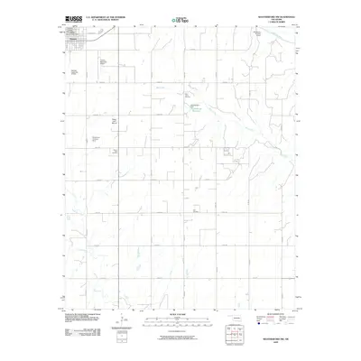
2009 Map of Weatherford NW
USGS Topo · Published 2009About this map
The town of Thomas anchors the northwest corner of this rural landscape, which is defined by the agricultural grid of Custer County and the meandering path of Bear Creek. The terrain is punctuated by significant landmarks like Sugar Loaf Mound and the waters of Kippinberger Reservoir, held by the Kippinberger Dam. For those interested in local history and genealogy, the map identifies several burial sites including Mound Olive Cemetery, Saint Johns Cemetery, and Zion Cemetery, each serving as a focal point for the surrounding farming community. Transportation and local utility are represented by the Thomas Municipal Airport, the Hutchinson Landing Strip, and numerous water management sites such as R Wickham Number 2 Dam and the Cowden Laterals Site 1 Dam. The northeastern edge of the sheet is marked by the broad course of the Canadian River, which forms a natural boundary against the geometric road network.
Find a feature on this map
31 named features on this map. Tap any name to fly to it.
Don’t see what you’re looking for? This feature index may not catch every label — zoom into the map to look around manually.
Map Details
Editions of this 2009 Weatherford NW Map
This is the sole edition of this map. No revisions or reprints were ever made.
Other maps of this area

1955 · Clinton
USGS Topo · 1:250,000

1957 · Clinton
USGS Topo · 1:250,000

1957 · Clinton
USGS Topo · 1:62,500

1962 · Putnam
USGS Topo · 1:62,500

1964 · Oakwood
USGS Topo · 1:62,500

1964 · Weatherford
USGS Topo · 1:62,500

1976 · Clinton SE
USGS Topo · 1:24,000

1976 · Clinton NE
USGS Topo · 1:24,000
1983 · Indianapolis
USGS Topo · 1:24,000
1983 · Clinton NE
USGS Topo · 1:24,000