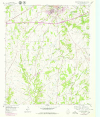
1959 Map of Weatherford South
USGS Topo · Published 1979About this map
Weatherford anchors the northern edge of this Parker County landscape, showing the city's southward expansion as recorded in the late 1950s and updated through the 1970s. The terrain is defined by the winding paths of Sanchez Creek and East Sanchez Creek, where the rural character is evidenced by numerous small family-named crossings and landmark institutions. Local history is deeply embedded in the rural plots, featuring several religious and memorial sites such as Spring Creek Ch and the Blackwell Cem in the southeast.
Find a feature on this map
30 named features on this map. Tap any name to fly to it.
Don’t see what you’re looking for? This feature index may not catch every label — zoom into the map to look around manually.
Map Details
Editions of this 1959 Weatherford South Map
Other maps of this area

1891 · Weatherford
USGS Topo · 1:125,000

1893 · Weatherford
USGS Topo · 1:125,000

1924 · Weatherford 3-d
USGS Topo · 1:48,000

1931 · Dennis
USGS Topo · 1:62,500

1932 · Springtown
USGS Topo · 1:62,500

1954 · Dallas
USGS Topo · 1:250,000

1958 · Dallas
USGS Topo · 1:250,000
1958 · Chapin
USGS Topo · 1:24,000
1959 · Lake Weatherford
USGS Topo · 1:24,000
1959 · Tin Top
USGS Topo · 1:24,000