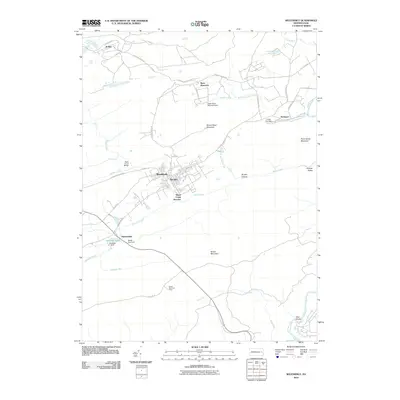
2010 Map of Weatherly
USGS Topo · Published 2010About this map
Weatherly serves as the central hub of this Carbon County landscape, where the confluence of Koons Creek and Black Creek dictated the early layout of the town. The terrain is defined by the massive ridge of Broad Mountain to the south and the steep descent toward the Lehigh River at the eastern boundary. This 2010 survey shows the intricate relationship between the region's industrial past and its topography, notably at Black Creek Junction and the isolated settlement of Eckley. Water management is prominent throughout the quadrangle, with features like Quakake Dam, Indian Run Dam, and Beisel Run Dam appearing alongside the numerous runs and creeks that carve through Hinkles Valley and Brushy Hollow. From the high point of Broad Mountain Tower to the riverside at Glen Onoko, the map traces the legacy of transit and resource extraction in the Pennsylvania anthracite region.
Find a feature on this map
50 named features on this map. Tap any name to fly to it.
Don’t see what you’re looking for? This feature index may not catch every label — zoom into the map to look around manually.
Map Details
Editions of this 2010 Weatherly Map
This is the sole edition of this map. No revisions or reprints were ever made.
Other maps of this area

1889 · Hazleton
USGS Topo · 1:62,500

1891 · Wilkesbarre
USGS Topo · 1:62,500

1891 · Hazleton
USGS Topo · 1:62,500

1893 · Hazleton
USGS Topo · 1:62,500

1894 · Wilkesbarre
USGS Topo · 1:62,500

1922 · Mauch Chunk
USGS Topo · 1:62,500

1922 · Stoddartsville
USGS Topo · 1:62,500

1924 · Stoddartsville
USGS Topo · 1:62,500

1924 · Mauch Chunk
USGS Topo · 1:62,500

1943 · Scranton
USGS Topo · 1:125,000