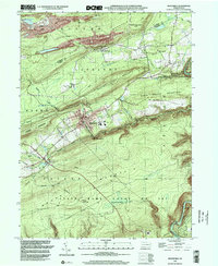
1999 Map of Weatherly
USGS Topo · Published 2002About this map
Weatherly stands as the central hub of this anthracite-region landscape, situated at the confluence of several steep mountain valleys where Hazle Creek and Beaver Creek join to form Black Creek. The industrial legacy of the area is evident in the presence of a Strip Mine and the rail infrastructure of the Lehigh Valley Railroad, which follows the winding course of the creeks through the high ridges. To the north, the village of Eckley sits on the plateau of Foster Mountain, while the southern reaches of the map are defined by the deep incision of the Lehigh Gorge. The topography is dominated by parallel ridges like Lausanne Mountain and Spring Mountain, creating a corridor that constrained early settlement to narrow valley floors and facilitated the development of critical junctions like Black Creek Junction and Hudsondale. Large tracts of preserved land, including State Game Lands No 149 and Lehigh Gorge State Park, now cover much of the terrain formerly shaped by the coal and rail industries.
Find a feature on this map
42 named features on this map. Tap any name to fly to it.
Don’t see what you’re looking for? This feature index may not catch every label — zoom into the map to look around manually.
Map Details
Editions of this 1999 Weatherly Map
This is the sole edition of this map. No revisions or reprints were ever made.
Other maps of this area

1889 · Hazleton
USGS Topo · 1:62,500

1891 · Wilkesbarre
USGS Topo · 1:62,500

1891 · Hazleton
USGS Topo · 1:62,500

1893 · Hazleton
USGS Topo · 1:62,500

1894 · Wilkesbarre
USGS Topo · 1:62,500

1922 · Mauch Chunk
USGS Topo · 1:62,500

1922 · Stoddartsville
USGS Topo · 1:62,500

1924 · Stoddartsville
USGS Topo · 1:62,500

1924 · Mauch Chunk
USGS Topo · 1:62,500

1943 · Scranton
USGS Topo · 1:125,000