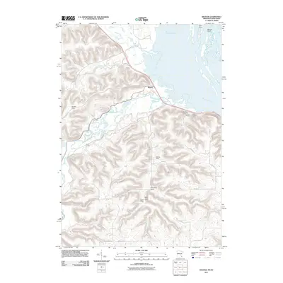
2011 Map of Weaver
USGS Topo · Published 2011About this map
The Mississippi River bottomlands and the bluff country of Buffalo County meet in this 2011 survey, centered on the settlement of Weaver. The landscape is defined by the complex hydrology of the river corridor, including the expansive Prichard Lake and the managed waters of Dorer Pools. Inland, the terrain rises sharply toward Hoosier Ridge, cut by several distinct drainages including Adams Valley and Hidershide Valley. For those researching local family history, the map identifies several burial sites clustered near the river valley, most notably Saint Marys Cemetery, Evergreen Cemetery, and Hillside Cemetery, along with the more isolated Young Cemetery to the west. This era shows the developed road network, including County Hwy-26 and County Hwy-28, which follow the natural contours of the river terrace and the interior coulees.
Find a feature on this map
34 named features on this map. Tap any name to fly to it.
Don’t see what you’re looking for? This feature index may not catch every label — zoom into the map to look around manually.
Map Details
Editions of this 2011 Weaver Map
This is the sole edition of this map. No revisions or reprints were ever made.
Other maps of this area

1932 · Cochrane
USGS Topo · 1:62,500

1932 · Wabasha
USGS Topo · 1:62,500

1932 · Alma
USGS Topo · 1:62,500

1934 · Plainview
USGS Topo · 1:62,500

1934 · Cochrane
USGS Topo · 1:62,500

1937 · Cochrane
USGS Topo · 1:62,500

1938 · Plainview
USGS Topo · 1:62,500

1950 · Alma
USGS Topo · 1:62,500

1951 · Wabasha
USGS Topo · 1:62,500

1953 · Saint Paul
USGS Topo · 1:250,000