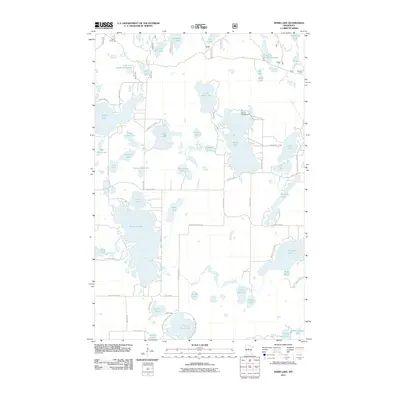
2011 Map of Webb Lake
USGS Topo · Published 2011About this map
The Boy River meanders through a dense network of glacial lakes and wetlands in this Cass County landscape. The area is dominated by significant water bodies including Webb Lake, Pleasant Lake, and Stony Lake, which are interconnected by a modern road network such as County Hwy 5 and County Hwy 46. The presence of the Deep Portage Reserve and Mascot Campgrounds indicates the region's long-standing transition toward conservation and recreation. Local landmarks like Arthurs Point and Ogema Point provide geographic orientation among the dozens of smaller basins like Trillium Lake, Blueberry Lake, and Woodchuck Lake. This survey illustrates the intricate drainage patterns of the Minnesota north woods, where small streams and river bends tie together a patchwork of named lakes and varied shorelines.
Find a feature on this map
59 named features on this map. Tap any name to fly to it.
Don’t see what you’re looking for? This feature index may not catch every label — zoom into the map to look around manually.
Map Details
Editions of this 2011 Webb Lake Map
This is the sole edition of this map. No revisions or reprints were ever made.
Other maps of this area

1953 · Brainerd
USGS Topo · 1:250,000

1954 · Bemidji
USGS Topo · 1:250,000

1957 · Brainerd
USGS Topo · 1:250,000

1957 · Bemidji
USGS Topo · 1:250,000

1958 · Bemidji
USGS Topo · 1:250,000

1958 · Brainerd
USGS Topo · 1:250,000

1965 · Brainerd
USGS Topo · 1:250,000

1970 · Backus
USGS Topo · 1:24,000

1970 · Hackensack
USGS Topo · 1:24,000
1970 · Mildred
USGS Topo · 1:24,000