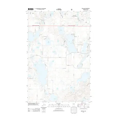
2013 Map of Webb Lake
USGS Topo · Published 2013About this map
The Chippewa National Forest dominates this northern landscape, defined by a dense network of glacial lakes and wetlands. The central hub is Webb Lake, featuring the Webb Lake Airport and Mascot Campgrounds on its northern shores. A complex web of forest routes and local roads, such as Woodtick Trl and Warbler Dr NW, provides access to the numerous water bodies that dot the terrain, including Little Webb Lake, Long Lake, and Stony Lake. The naming conventions of these features, like Lake Four Hundred Eighteen and N Stocking Lake, suggest a history of early surveying and local descriptive labeling. The transition between managed forest land and private recreational areas is evident in the layout of roads like Ogema Point Dr NW and Birch Lake Township Road 90, which connect seasonal residences and camps to the larger county highway system.
Find a feature on this map
82 named features on this map. Tap any name to fly to it.
Don’t see what you’re looking for? This feature index may not catch every label — zoom into the map to look around manually.
Map Details
Editions of this 2013 Webb Lake Map
This is the sole edition of this map. No revisions or reprints were ever made.
Other maps of this area

1953 · Brainerd
USGS Topo · 1:250,000

1954 · Bemidji
USGS Topo · 1:250,000

1957 · Brainerd
USGS Topo · 1:250,000

1957 · Bemidji
USGS Topo · 1:250,000

1958 · Bemidji
USGS Topo · 1:250,000

1958 · Brainerd
USGS Topo · 1:250,000

1965 · Brainerd
USGS Topo · 1:250,000

1970 · Backus
USGS Topo · 1:24,000

1970 · Hackensack
USGS Topo · 1:24,000
1970 · Mildred
USGS Topo · 1:24,000