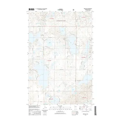
2016 Map of Webb Lake
USGS Topo · Published 2016About this map
Chippewa National Forest encompasses the northern portion of this landscape, a glaciated terrain defined by an intricate network of kettle lakes and wetlands. The central feature, Webb Lake, is surrounded by smaller water bodies including Little Webb Lake, Blueberry Lake, and Surprise Lake. Aviation infrastructure is represented by the Webb Lake Airport, positioned on a narrow neck of land between these waters. The map reveals a transition from the protected forest boundaries to the north into a more fragmented pattern of development to the south, where roads like Woman Lake Rd and Washington Ave NW provide access to seasonal homes and recreational properties. Notable water bodies such as Stony Lake, High Bank Lake, and Boss Lake further illustrate the water-dominated geography of Cass County, while numerous township and range lines, including t141n r30w, indicate the underlying public land survey system.
Find a feature on this map
78 named features on this map. Tap any name to fly to it.
Don’t see what you’re looking for? This feature index may not catch every label — zoom into the map to look around manually.
Map Details
Editions of this 2016 Webb Lake Map
This is the sole edition of this map. No revisions or reprints were ever made.
Other maps of this area

1953 · Brainerd
USGS Topo · 1:250,000

1954 · Bemidji
USGS Topo · 1:250,000

1957 · Brainerd
USGS Topo · 1:250,000

1957 · Bemidji
USGS Topo · 1:250,000

1958 · Bemidji
USGS Topo · 1:250,000

1958 · Brainerd
USGS Topo · 1:250,000

1965 · Brainerd
USGS Topo · 1:250,000

1970 · Backus
USGS Topo · 1:24,000

1970 · Hackensack
USGS Topo · 1:24,000
1970 · Mildred
USGS Topo · 1:24,000