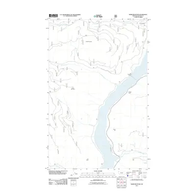
2011 Map of Webb Mountain
USGS Topo · Published 2011About this map
Lake Koocanusa dominates the central valley of this Lincoln County landscape, a massive reservoir created by the Libby Dam. The 2011 survey details the interface between the water and the rising terrain of the Kootenai National Forest. The Koocanusa Bridge provides a vital crossing point, connecting the western slopes near Webb Mountain and Scalp Mountain to the eastern banks. Notable natural landmarks include the verticality of Stone Hill and the remote Sutton Creek Falls. The map documents a network of Forest Service infrastructure, such as the Natl Forest Develop Road 337 Rd and Webb Mtn Rd, which provide access to drainage features like Holdup Gulch and Simons Draw. This cartographic record is essential for understanding the modern geography of this managed wilderness and its significant riparian corridors.
Find a feature on this map
18 named features on this map. Tap any name to fly to it.
Don’t see what you’re looking for? This feature index may not catch every label — zoom into the map to look around manually.
Map Details
Editions of this 2011 Webb Mountain Map
This is the sole edition of this map. No revisions or reprints were ever made.
Other maps of this area

1957 · Kalispell
USGS Topo · 1:250,000

1960 · Kalispell
USGS Topo · 1:250,000

1961 · Kalispell
USGS Topo · 1:250,000

1963 · Rexford
USGS Topo · 1:24,000

1963 · Robinson Mountain
USGS Topo · 1:24,000

1963 · Mc Guire Mountain
USGS Topo · 1:24,000

1963 · Red Mountain
USGS Topo · 1:24,000

1963 · Webb Mountain
USGS Topo · 1:24,000

1963 · Boulder Lakes
USGS Topo · 1:24,000
1963 · Inch Mountain
USGS Topo · 1:24,000