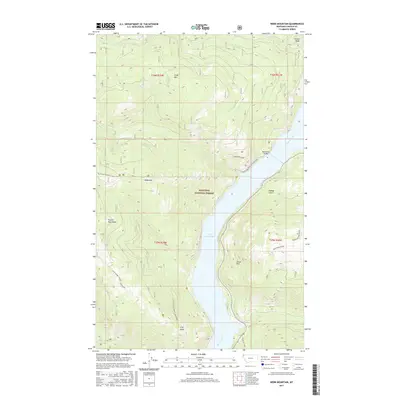
2017 Map of Webb Mountain
USGS Topo · Published 2017About this map
Lake Koocanusa and the Kootenai River dominate the central corridor of this Lincoln County landscape, dividing the Purcell Mountains to the west from the varied peaks and draws to the east. The waterway is spanned by the Koocanusa Bridge, a vital link for the managed lands of the Kootenai National Forest. Significant elevation changes are marked by peaks such as Webb Mtn and Scalp Mtn, while the Pacific NW National Scenic Trail winds through the high country. To the southeast, Beartrap Ponds and Sutton Creek Falls indicate the diverse hydrography of the region. The map captures a wilderness area defined by forestry management and recreational infrastructure, including locations like Stone Hill and the dual-named peak of Cliff Point / Thirsty Mountain.
Find a feature on this map
23 named features on this map. Tap any name to fly to it.
Don’t see what you’re looking for? This feature index may not catch every label — zoom into the map to look around manually.
Map Details
Editions of this 2017 Webb Mountain Map
This is the sole edition of this map. No revisions or reprints were ever made.
Other maps of this area

1957 · Kalispell
USGS Topo · 1:250,000

1960 · Kalispell
USGS Topo · 1:250,000

1961 · Kalispell
USGS Topo · 1:250,000

1963 · Rexford
USGS Topo · 1:24,000

1963 · Robinson Mountain
USGS Topo · 1:24,000

1963 · Mc Guire Mountain
USGS Topo · 1:24,000

1963 · Red Mountain
USGS Topo · 1:24,000

1963 · Webb Mountain
USGS Topo · 1:24,000

1963 · Boulder Lakes
USGS Topo · 1:24,000
1963 · Inch Mountain
USGS Topo · 1:24,000