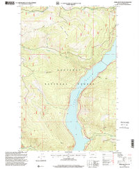
1997 Map of Webb Mountain
USGS Topo · Published 2000About this map
Lake Koocanusa dominates the central landscape of this 1997 revision, reflecting a high-elevation reservoir environment within the Kootenai National Forest. The map documents a rugged section of Lincoln County where steep timbered ridges are punctuated by peaks like Scalp Mountain and Webb Mountain Lookout. Water management and natural drainage are central themes, as numerous drainages including South Fork Sullivan Creek and Boulder Creek feed into the lake. Evidence of resource extraction is visible at a Quarry near Sullivan Creek, while prominent landmarks like Stone Hill and Cliff Point provide clear reference points for navigation through the mountainous terrain. The map's detail is particularly useful for identifying forest roads and high-altitude lookouts used for fire monitoring and land management during the late 20th century.
Find a feature on this map
15 named features on this map. Tap any name to fly to it.
Don’t see what you’re looking for? This feature index may not catch every label — zoom into the map to look around manually.
Map Details
Editions of this 1997 Webb Mountain Map
This is the sole edition of this map. No revisions or reprints were ever made.
Other maps of this area

1957 · Kalispell
USGS Topo · 1:250,000

1960 · Kalispell
USGS Topo · 1:250,000

1961 · Kalispell
USGS Topo · 1:250,000

1963 · Rexford
USGS Topo · 1:24,000

1963 · Robinson Mountain
USGS Topo · 1:24,000

1963 · Mc Guire Mountain
USGS Topo · 1:24,000

1963 · Red Mountain
USGS Topo · 1:24,000

1963 · Webb Mountain
USGS Topo · 1:24,000

1963 · Boulder Lakes
USGS Topo · 1:24,000
1963 · Inch Mountain
USGS Topo · 1:24,000