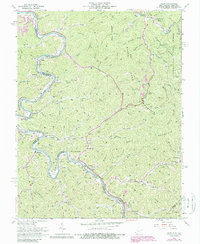
1963 Map of Webb
USGS Topo · Published 1989About this map
The Tug Fork carves a serpentine path along the border of West Virginia and Kentucky, serving as the dominant geographic and industrial artery for this region during the 1960s. Along its banks, the Norfolk and Western railway links small riverfront communities like Webb, Crum, and Kermit. The landscape is defined by the extraction of natural resources, evidenced by the numerous Gas Wells and Mines peppered throughout the hollows and ridges of Bull Mountain and Wells Mountain.
Find a feature on this map
74 named features on this map. Tap any name to fly to it.
Don’t see what you’re looking for? This feature index may not catch every label — zoom into the map to look around manually.
Map Details
Editions of this 1963 Webb Map
4 editions found
Other maps of this area

1886 · Prestonsburg
USGS Topo · 1:125,000

1887 · Warfield
USGS Topo · 1:125,000

1891 · Warfield
USGS Topo · 1:125,000

1892 · Prestonsburg
USGS Topo · 1:125,000

1892 · Huntington
USGS Topo · 1:125,000

1898 · Huntington
USGS Topo · 1:125,000

1903 · Kenova
USGS Topo · 1:125,000

1904 · Kenova
USGS Topo · 1:125,000

1909 · Wayne
USGS Topo · 1:62,500

1910 · Naugatuck
USGS Topo · 1:48,000