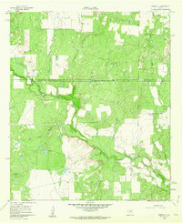
1960 Map of Webbville
USGS Topo · Published 1962About this map
Pecan Bayou and its many tributaries, including Little Pecan Bayou and Rocky Branch, dominate this West Texas landscape along the border of Coleman and Callahan counties. The map captures a unique moment in local administrative history, explicitly noting that the Coleman-Callahan County line is in dispute, referencing surveying efforts dating back to 1888. The small settlement of Webbville sits near the eastern edge of the quadrangle, while the western portion shows significant resource extraction at the Anzah Morris Oil Field. Scattered Oil Wells and the Adams Cem provide specific points of interest for genealogists and industrial historians tracing the mid-century development of the region. The terrain is defined by drainage patterns like Wolf Hollow and Live Oak Branch, showing the rural character of the area before modern expansion.
Find a feature on this map
14 named features on this map. Tap any name to fly to it.
Don’t see what you’re looking for? This feature index may not catch every label — zoom into the map to look around manually.
Map Details
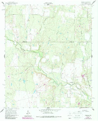
Editions of this 1960 Webbville Map
2 editions found
Other maps of this area

1887 · Coleman
USGS Topo · 1:125,000

1889 · Coleman
USGS Topo · 1:125,000

1924 · Brownwood Reservoir Site
USGS Topo · 1:48,000

1927 · Grosvenor
USGS Topo · 1:62,500

1931 · Baird
USGS Topo · 1:125,000

1932 · Baird
USGS Topo · 1:125,000

1954 · Brownwood
USGS Topo · 1:250,000

1954 · Abilene
USGS Topo · 1:250,000

1958 · Abilene
USGS Topo · 1:250,000

1960 · Lake Scarborough
USGS Topo · 1:24,000