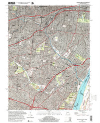
1998 Map of Webster Groves
USGS Topo · Published 1999About this map
Jefferson Barracks and its adjacent National Cemetery anchor the southern riverfront of this St. Louis suburban landscape at the close of the twentieth century. The map reveals a dense network of established municipalities, including Webster Groves, Shrewsbury, and Maplewood, which are integrated into the larger metropolitan area by the St Louis San Francisco RR and the Missouri Pacific RR. The area’s spiritual and commemorative history is exceptionally prominent, with massive burial grounds like Resurrection Cemetery, St Peter and Paul Cemetery, and Lakewood Park Cemetery occupying significant acreage.
Find a feature on this map
72 named features on this map. Tap any name to fly to it.
Don’t see what you’re looking for? This feature index may not catch every label — zoom into the map to look around manually.
Map Details
Editions of this 1998 Webster Groves Map
2 editions found
Other maps of this area

1888 · St. Louis
USGS Topo · 1:62,500

1910 · Waterloo
USGS Topo · 1:62,500

1912 · Kimmswick
USGS Topo · 1:62,500

1913 · Waterloo
USGS Topo · 1:62,500

1916 · Kimmswick
USGS Topo · 1:62,500

1933 · Creve Coeur
USGS Topo · 1:24,000

1933 · Granite City
USGS Topo · 1:24,000

1933 · Jefferson Barracks
USGS Topo · 1:24,000

1933 · Cahokia
USGS Topo · 1:24,000

1933 · Clayton
USGS Topo · 1:24,000