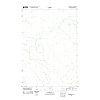
2011 Map of Webster NE
USGS Topo · Published 2011About this map
Little Beaver Creek and its many meandering tributaries define this stretch of the high plains along the border of Montana and North Dakota. This map captures the rural topography of Fallon County, characterized by a complex drainage system that includes Buffalo Creek in the north and Big Gumbo Creek to the south. Human influence is sparse and highly specific to the ranching landscape, highlighted by features like the Bradac Dam and the simple path of Country Rd 4. The map provides a detailed view of the water-management and transport infrastructure required for agriculture in this arid environment, showing the relationship between small-scale dams and the natural creek beds they manage.
Find a feature on this map
5 named features on this map. Tap any name to fly to it.
Don’t see what you’re looking for? This feature index may not catch every label — zoom into the map to look around manually.
Map Details
Editions of this 2011 Webster NE Map
This is the sole edition of this map. No revisions or reprints were ever made.
Other maps of this area

1953 · Miles City
USGS Topo · 1:250,000

1953 · Dickinson
USGS Topo · 1:250,000

1957 · Dickinson
USGS Topo · 1:250,000

1957 · Miles City
USGS Topo · 1:250,000

1958 · Miles City
USGS Topo · 1:250,000

1973 · Kid Creek
USGS Topo · 1:24,000
1973 · Cedar Ridge
USGS Topo · 1:24,000

1980 · Marmarth
USGS Topo · 1:24,000

1981 · Webster NW
USGS Topo · 1:24,000

1981 · Baker
USGS Topo · 1:100,000