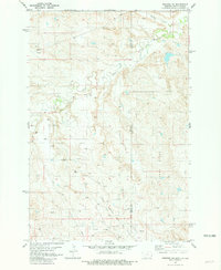
1981 Map of Webster NE
USGS Topo · Published 1981About this map
Little Beaver East Oil Field dominates the southern landscape of this 1981 survey, where the prairie of Bowman County meets the state border. This industrial footprint is defined by dozens of individual Oil Wells and Gas Wells that dot the section lines, revealing the energy production that shaped the local economy during the early 1980s. The terrain is bifurcated by the winding course of Little Beaver Creek and its northern counterpart, Buffalo Creek, while the prominent rise of Sunny Slope provides a notable landmark in the eastern portion of the quadrangle. Straddling the Montana and North Dakota border, the map documents the intersection of rural hydrology and resource extraction, capturing a moment when petroleum development was at its peak across the high plains of the Fallon and Bowman county line.
Find a feature on this map
11 named features on this map. Tap any name to fly to it.
Don’t see what you’re looking for? This feature index may not catch every label — zoom into the map to look around manually.
Map Details
Editions of this 1981 Webster NE Map
This is the sole edition of this map. No revisions or reprints were ever made.
Other maps of this area

1953 · Miles City
USGS Topo · 1:250,000

1953 · Dickinson
USGS Topo · 1:250,000

1957 · Dickinson
USGS Topo · 1:250,000

1957 · Miles City
USGS Topo · 1:250,000

1958 · Miles City
USGS Topo · 1:250,000

1973 · Kid Creek
USGS Topo · 1:24,000
1973 · Cedar Ridge
USGS Topo · 1:24,000

1980 · Marmarth
USGS Topo · 1:24,000

1981 · Webster NW
USGS Topo · 1:24,000

1981 · Baker
USGS Topo · 1:100,000