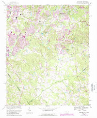
1968 Map of Weddington
USGS Topo · Published 1989About this map
The boundary between Mecklenburg Co and Union Co anchor this landscape during a period of transition, where the expanding southern reaches of Charlotte meet rural townships. Notable for its network of watercourses, the area is defined by McAlpine Creek and Sixmile Creek, which drain the undulating terrain. Local social and educational centers are prominent, including South Mecklenburg High Sch and Quail Hollow Jr High Sch.
Find a feature on this map
33 named features on this map. Tap any name to fly to it.
Don’t see what you’re looking for? This feature index may not catch every label — zoom into the map to look around manually.
Map Details
Editions of this 1968 Weddington Map
4 editions found
Other maps of this area

1905 · Charlotte
USGS Topo · 1:48,000

1907 · Charlotte
USGS Topo · 1:62,500

1941 · Charlotte
USGS Topo · 1:125,000

1941 · Spartanburg
USGS Topo · 1:250,000

1942 · Charlotte
USGS Topo · 1:125,000

1948 · Charlotte East
USGS Topo · 1:24,000

1948 · Charlotte West
USGS Topo · 1:24,000

1949 · Charlotte West
USGS Topo · 1:24,000

1949 · Charlotte East
USGS Topo · 1:24,000

1949 · Wilgrove
USGS Topo · 1:24,000