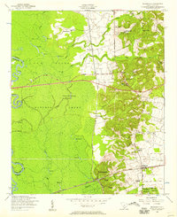
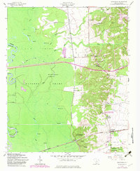
1953 Map of Wedgefield
USGS Topo · Published 1957About this map
The Wateree Swamp dominates the western landscape of this 1950s survey, a dense network of oxbows and backwaters including Hurricane Lake and Jack Hole along the Richland and Sumter county line. Rising above the lowlands to the east, the terrain transitions into the high hills of Stateburg, a region marked by significant cultural landmarks such as the Church of the Holy Cross and General Sumters Tomb. The map illustrates a rural society organized around crossroads and country schools, with Claremont and Wedgefield serving as key rail-side hubs.
Find a feature on this map
42 named features on this map. Tap any name to fly to it.
Don’t see what you’re looking for? This feature index may not catch every label — zoom into the map to look around manually.
Map Details
Editions of this 1953 Wedgefield Map
3 editions found
Other maps of this area

1938 · Hagood
USGS Topo · 1:62,500

1941 · Spartanburg
USGS Topo · 1:250,000

1942 · Camden
USGS Topo · 1:125,000

1943 · Eastover
USGS Topo · 1:62,500

1946 · Sumter
USGS Topo · 1:62,500

1953 · Poinsett State Park
USGS Topo · 1:24,000

1953 · Eastover
USGS Topo · 1:24,000

1953 · Wedgefield
USGS Topo · 1:24,000

1953 · Wateree
USGS Topo · 1:24,000

1953 · Rembert
USGS Topo · 1:24,000