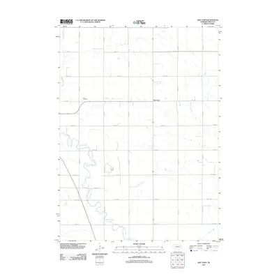
2011 Map of Wee Town
USGS Topo · Published 2011About this map
Wee Town sits at a rural crossroads in Pierce County, where a strictly rectangular grid of county roads meets the winding path of the North Fork Elkhorn River. This 2011 survey illustrates the modern agricultural landscape of northeast Nebraska, defined by a meticulously planned network of sections and ranges. The river itself cuts a serpentine course across the southwestern corner of the quadrangle, contrasting the straight lines of routes like 854th Rd and 554th Ave. Genealogists and local historians will find the location of Zion Cemetery in the northwestern quadrant, a quiet landmark amidst the vast fields. The drainage patterns of the region are further marked by Yankton Slough and Turtle Creek, which underscore the importance of water management in this high-plains farming community.
Find a feature on this map
21 named features on this map. Tap any name to fly to it.
Don’t see what you’re looking for? This feature index may not catch every label — zoom into the map to look around manually.
Map Details
Editions of this 2011 Wee Town Map
This is the sole edition of this map. No revisions or reprints were ever made.
Other maps of this area

1955 · Sioux City
USGS Topo · 1:250,000

1958 · Sioux City
USGS Topo · 1:250,000

1959 · Sioux City
USGS Topo · 1:250,000

1963 · Hoskins
USGS Topo · 1:24,000

1963 · Pierce SE
USGS Topo · 1:24,000

1963 · Norfolk
USGS Topo · 1:24,000

1963 · Osmond
USGS Topo · 1:24,000

1963 · Wee Town
USGS Topo · 1:24,000
1963 · Pierce
USGS Topo · 1:24,000

1963 · Norfolk NE
USGS Topo · 1:24,000