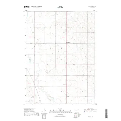
2017 Map of Wee Town
USGS Topo · Published 2017About this map
Wee Town serves as a central point in this rural landscape of Pierce County, where a grid of section lines and gravel roads like 854th Rd and 555th Ave defines the agricultural layout. The terrain is marked by the meandering path of the North Fork Elkhorn River, which winds through the southwestern corner of the quadrangle. This watercourse, along with Turtle Cr and Yankton Slough, provided essential drainage for the surrounding farmland during this era of modern Nebraska agriculture. Genealogists may find interest in the Zion Cem, located just west of the main settlement area along a quiet section line. The map illustrates the persistent structure of the Public Land Survey System, with boundaries such as t26n r1w and t26n r2w framing the local townships.
Find a feature on this map
24 named features on this map. Tap any name to fly to it.
Don’t see what you’re looking for? This feature index may not catch every label — zoom into the map to look around manually.
Map Details
Editions of this 2017 Wee Town Map
This is the sole edition of this map. No revisions or reprints were ever made.
Other maps of this area

1955 · Sioux City
USGS Topo · 1:250,000

1958 · Sioux City
USGS Topo · 1:250,000

1959 · Sioux City
USGS Topo · 1:250,000

1963 · Hoskins
USGS Topo · 1:24,000

1963 · Pierce SE
USGS Topo · 1:24,000

1963 · Norfolk
USGS Topo · 1:24,000

1963 · Osmond
USGS Topo · 1:24,000

1963 · Wee Town
USGS Topo · 1:24,000
1963 · Pierce
USGS Topo · 1:24,000

1963 · Norfolk NE
USGS Topo · 1:24,000