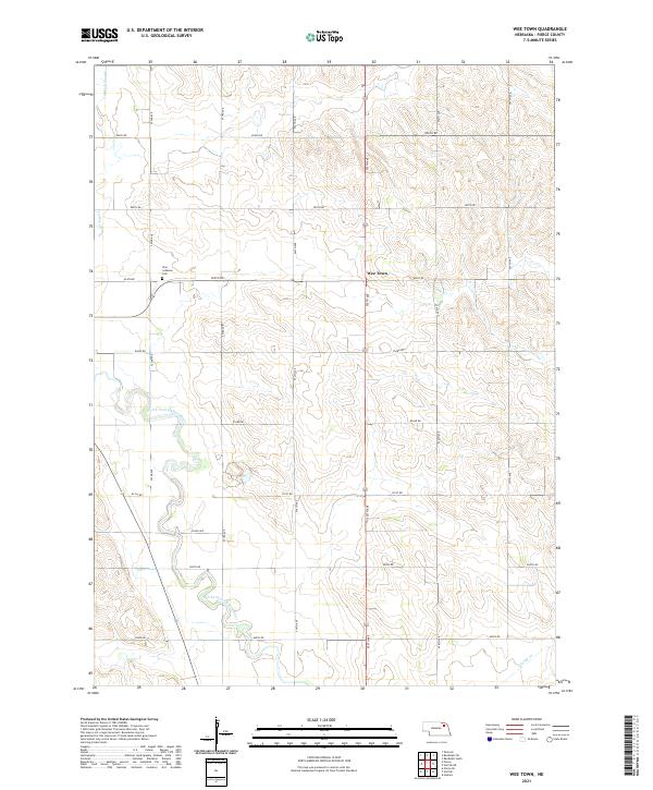
2021 Map of Wee Town
USGS Topo · Published 2021About this map
Wee Town serves as the focal point of this agricultural landscape in Pierce County, Nebraska, where the section-line road network creates a rigid grid over the undulating terrain. The community is situated near the intersection of 555th Ave and 854th Rd, just east of the Zion Lutheran Cem. Water defines the lower elevations, notably where the North Fork Elkhorn River meanders across the southwestern portion of the sheet. To the northwest, the seasonal drainage of Yankton Slough and the southeastern reach of Turtle Cr illustrate the hydrological patterns that have influenced land use and farmstead placement for generations. This survey captures the rural character of the region, emphasizing the relationship between established cemeteries, named creeks, and the gravel roads that connect this prairie settlement to the surrounding townships.
Find a feature on this map
24 named features on this map. Tap any name to fly to it.
Don’t see what you’re looking for? This feature index may not catch every label — zoom into the map to look around manually.
Map Details
Editions of this 2021 Wee Town Map
This is the sole edition of this map. No revisions or reprints were ever made.
Other maps of this area

1955 · Sioux City
USGS Topo · 1:250,000

1958 · Sioux City
USGS Topo · 1:250,000

1959 · Sioux City
USGS Topo · 1:250,000

1963 · Hoskins
USGS Topo · 1:24,000

1963 · Pierce SE
USGS Topo · 1:24,000

1963 · Norfolk
USGS Topo · 1:24,000

1963 · Osmond
USGS Topo · 1:24,000

1963 · Wee Town
USGS Topo · 1:24,000
1963 · Pierce
USGS Topo · 1:24,000

1963 · Norfolk NE
USGS Topo · 1:24,000