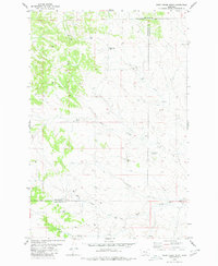
1980 Map of Weed Creek West
USGS Topo · Published 1980About this map
The intersection of Rosebud, Musselshell, and Yellowstone Counties defines this high-plains landscape, where the geography is marked by isolated landmarks and seasonal watercourses. The 1980 survey reveals a quiet interior dominated by ranching and resource extraction, evidenced by several Wells and a Mine scattered across the undulating terrain. Local genealogy is anchored by the Cabin Creek Cemetery and an isolated Grave located north of Lemonade Spring.
Find a feature on this map
13 named features on this map. Tap any name to fly to it.
Don’t see what you’re looking for? This feature index may not catch every label — zoom into the map to look around manually.
Map Details
Editions of this 1980 Weed Creek West Map
This is the sole edition of this map. No revisions or reprints were ever made.
Other maps of this area

1954 · Forsyth
USGS Topo · 1:250,000

1957 · Forsyth
USGS Topo · 1:250,000

1958 · Forsyth
USGS Topo · 1:250,000

1962 · Queens Point
USGS Topo · 1:24,000

1962 · Guthridge Ranch
USGS Topo · 1:24,000

1963 · Melstone
USGS Topo · 1:24,000

1979 · Melstone
USGS Topo · 1:100,000

1979 · Hysham
USGS Topo · 1:100,000
1980 · Weed Creek East
USGS Topo · 1:24,000
1980 · Pine View
USGS Topo · 1:24,000