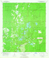
1954 Map of Weekiwachee Springs
USGS Topo · Published 1964About this map
Weekiwachee Springs flows as a central landmark in this mid-century survey of coastal Hernando County. The landscape is dominated by the sprawling Chassahowitzka Swamp and the protected lands of the Chassahowitzka National Wildlife Refuge to the west. While much of the terrain is defined by wetlands and intricate water systems like the Weekiwachee River, the map also documents the sparse human presence of the era. The small settlement of Berkeley sits in the south, while several family-named or local water bodies, including Tooke Lake, Whitehurst Pond, and Great Hope Pond, dot the inland topography. This 1954 mapping provides an look at the region's hydrology before later development, showing the original course of Salt Cr and the primitive road network that once connected these isolated spring-fed environments.
Find a feature on this map
11 named features on this map. Tap any name to fly to it.
Don’t see what you’re looking for? This feature index may not catch every label — zoom into the map to look around manually.
Map Details
Editions of this 1954 Weekiwachee Springs Map
3 editions found
Other maps of this area

1954 · Chassahowitzka Bay
USGS Topo · 1:24,000

1954 · Brooksville NW
USGS Topo · 1:24,000

1954 · Brooksville
USGS Topo · 1:24,000

1954 · Aripeka
USGS Topo · 1:24,000

1954 · Chassahowitzka
USGS Topo · 1:24,000

1954 · Bayport
USGS Topo · 1:24,000

1954 · Masaryktown
USGS Topo · 1:24,000

1954 · Weekiwachee Springs
USGS Topo · 1:24,000

1954 · Port Richey NE
USGS Topo · 1:24,000

1955 · Plant City
USGS Topo · 1:250,000