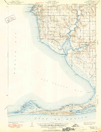
1943 Map of Weeks Bay
USGS Topo · Published 1950About this map
Mobile Bay and Bon Secour Bay define this coastal landscape, where the Fish River feeds into the sheltered waters of Weeks Bay. Surveyed just before the United States entered World War II, the map captures a network of small landing sites and established settlements like Battles Wharf, Point Clear, and Magnolia Springs. The presence of the Confederate Rest Cem and several rural schools such as Pt Clear Sch and Springhill Sch suggests a deeply rooted community structure along the eastern shore. To the south, the barrier peninsula separates Little Lagoon from the Gulf, showing the early layout of Gulf Highlands and Pine Beach near the Intracoastal Waterway. The interior is marked by diverse wetland features, including Ghost Head Swamp and Gum Swamp, which influenced the placement of early roads like Dixie Road.
Find a feature on this map
88 named features on this map. Tap any name to fly to it.
Don’t see what you’re looking for? This feature index may not catch every label — zoom into the map to look around manually.
Map Details
Editions of this 1943 Weeks Bay Map
3 editions found

Other maps of this area

1920 · Robertsdale
USGS Topo · 1:62,500

1921 · Bon Secour
USGS Topo · 1:62,500

1921 · Point Clear
USGS Topo · 1:62,500

1921 · Fairhope
USGS Topo · 1:62,500

1921 · Dauphin Island
USGS Topo · 1:62,500

1921 · Delchamps
USGS Topo · 1:62,500

1922 · Mobile
USGS Topo · 1:62,500

1939 · Daphne
USGS Topo · 1:31,680

1940 · Silverhill
USGS Topo · 1:31,680

1940 · Hollingers Island
USGS Topo · 1:31,680