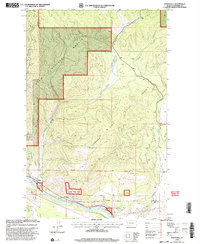
1999 Map of Weeksville
USGS Topo · Published 2003About this map
Clark Fork and the Thompson River meet in a landscape defined by sharp drainage systems and the vast boundaries of the Lolo National Forest. This 1999 revision of earlier 1960s topography reveals a late 20th-century view of the river-corridor settlements, including Weeksville and the riverside cluster known as The Pines. The map records the precise alignment of the Fifth Standard Parallel North, illustrating the intersection of the Public Land Survey System with the complex hydrology of Montana's mountain valleys. Small-scale industrial activity is noted near the river via the Substation and a Gravel Pit, while numerous named drainages like Bill Buffalo Creek, Lynch Creek, and Smiley Creek cut through the forest, detailing the intricate watershed of the region.
Find a feature on this map
17 named features on this map. Tap any name to fly to it.
Don’t see what you’re looking for? This feature index may not catch every label — zoom into the map to look around manually.
Map Details
Editions of this 1999 Weeksville Map
This is the sole edition of this map. No revisions or reprints were ever made.
Other maps of this area

1918 · St Regis
USGS Topo · 1:125,000

1919 · St. Regis
USGS Topo · 1:125,000

1937 · Thompson Falls
USGS Topo · 1:125,000

1956 · St Regis
USGS Topo · 1:62,500

1956 · Wallace
USGS Topo · 1:250,000

1959 · Plains
USGS Topo · 1:62,500

1960 · Wallace
USGS Topo · 1:250,000

1964 · Calico Creek
USGS Topo · 1:24,000
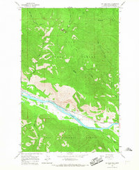
1964 · Big Hole Peak
USGS Topo · 1:24,000

1964 · Coney Peak
USGS Topo · 1:24,000