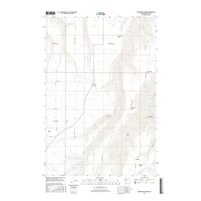
2017 Map of Weissenfels Ridge
USGS Topo · Published 2017About this map
Weissenfels Ridge defines the high ground of this Asotin County landscape, where the terrain is deeply incised by a network of steep draws and gulches. The small settlement of Craige sits in the southeastern corner, serving as a rare point of habitation in a region primarily shaped by its drainage patterns. Watercourses like Tenmile Cr, Mill Cr, and Kelly Cr carve through the plateau, creating the dramatic relief that dictates the placement of rural roads. Genealogists and local historians will find the Theon Cem situated along the western edge of the ridge, a quiet landmark amidst family-named features such as Ayers Gulch, Hoskins Gulch, and Beckman Gulch. This 2017 survey reveals how the modern road network, including Weissenfels Ridge Rd and Mill Creek Rd, continues to follow the natural contours of the land.
Find a feature on this map
28 named features on this map. Tap any name to fly to it.
Don’t see what you’re looking for? This feature index may not catch every label — zoom into the map to look around manually.
Map Details
Editions of this 2017 Weissenfels Ridge Map
This is the sole edition of this map. No revisions or reprints were ever made.
Other maps of this area

1944 · Anatone
USGS Topo · 1:62,500

1945 · Clarkston
USGS Topo · 1:62,500

1946 · Limekiln Rapids
USGS Topo · 1:62,500

1946 · Anatone
USGS Topo · 1:62,500

1948 · Clarkston
USGS Topo · 1:62,500

1955 · Pullman
USGS Topo · 1:250,000

1958 · Pullman
USGS Topo · 1:250,000

1958 · Lewiston Orchards South
USGS Topo · 1:24,000

1958 · Lewiston Orchards
USGS Topo · 1:62,500
1968 · Captain John Rapids
USGS Topo · 1:24,000