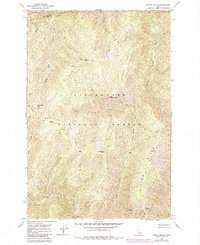
1966 Map of Weitas Butte
USGS Topo · Published 1984About this map
Lolo Trail and the Pack Trail follow the high ridgelines across the Clearwater National Forest in this 1960s survey of the North-Central Idaho backcountry. The landscape is defined by its topographic extremes, anchored by a Lookout Tower atop Weitas Butte and the smaller Little Weitas Butte to the south. This area straddles the boundary of Clearwater Co and Idaho Co, where the steep drainage of Weitas Creek and its tributaries like Little Weitas Creek cut through the high country. Historical passage through this region is marked by significant natural landmarks such as Weitas Meadows, Green Saddle, and Deep Saddle, which likely served as crucial navigation points along the ridgeline trails. To the west, Rocky Ridge Lake sits beneath the prominent Rocky Ridge, providing a rare water source in this high-altitude terrain.
Find a feature on this map
33 named features on this map. Tap any name to fly to it.
Don’t see what you’re looking for? This feature index may not catch every label — zoom into the map to look around manually.
Map Details
Editions of this 1966 Weitas Butte Map
2 editions found
Other maps of this area

1911 · Lolo
USGS Topo · 1:250,000

1913 · Lolo
USGS Topo · 1:250,000

1923 · Washington Creek
USGS Topo · 1:125,000

1924 · Weippe
USGS Topo · 1:125,000

1956 · Hamilton
USGS Topo · 1:250,000

1959 · Hamilton
USGS Topo · 1:250,000

1960 · Hamilton
USGS Topo · 1:250,000

1964 · Hamilton
USGS Topo · 1:250,000

1965 · Lean-to Point
USGS Topo · 1:24,000
1965 · Cook Mountain
USGS Topo · 1:24,000