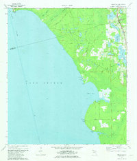
1970 Map of Welaka SE
USGS Topo · Published 1981About this map
The vast waters of Lake George and the St Johns River dominate this 1970 landscape, marking the transition between Putnam and Volusia counties. The shoreline is punctuated by historic access points like Barrs Landing, Pine Island Landing, and Deadman Landing, reflecting an era when the river served as a primary artery for movement through the Florida interior. These landings are connected by a network of inland tracks including Middle Road and Barrs Road, which snake through low-lying terrain drained by Tiger Branch and Jumping Gully Branch. In the northeastern corner, the Seaboard Coast Line railroad runs parallel to the water, passing a cluster of smaller lakes such as Davis Lake and Upper Louise Lake. The presence of the Lookout Tower Ruth near Willow Pt suggests the importance of fire observation and navigation in this heavily wooded and marshy region during the late twentieth century.
Find a feature on this map
26 named features on this map. Tap any name to fly to it.
Don’t see what you’re looking for? This feature index may not catch every label — zoom into the map to look around manually.
Map Details
Editions of this 1970 Welaka SE Map
4 editions found
Other maps of this area

1954 · Daytona Beach
USGS Topo · 1:250,000

1958 · Daytona Beach
USGS Topo · 1:250,000

1964 · Daytona Beach
USGS Topo · 1:250,000

1970 · Crescent City
USGS Topo · 1:24,000

1970 · Welaka SE
USGS Topo · 1:24,000

1970 · Welaka
USGS Topo · 1:24,000

1970 · Seville
USGS Topo · 1:24,000

1970 · Salt Springs
USGS Topo · 1:24,000

1970 · Pierson
USGS Topo · 1:24,000

1972 · Juniper Springs
USGS Topo · 1:24,000