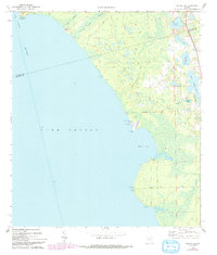
1970 Map of Welaka SE
USGS Topo · Published 1993About this map
The eastern shore of Lake George and the St Johns River define this map, illustrating the intricate marshy transition between open water and the Florida interior in the early 1970s. The coastline is marked by a series of historic points and coves, including Willow Cove, Ninemile Point, and Lake George Pt. Inland, the landscape is a network of smaller water bodies such as Silver Pond, Davis Lake, and the connected Upper Louise Lake and Lower Louise Lake.
Find a feature on this map
27 named features on this map. Tap any name to fly to it.
Don’t see what you’re looking for? This feature index may not catch every label — zoom into the map to look around manually.
Map Details
Editions of this 1970 Welaka SE Map
4 editions found
Other maps of this area

1954 · Daytona Beach
USGS Topo · 1:250,000

1958 · Daytona Beach
USGS Topo · 1:250,000

1964 · Daytona Beach
USGS Topo · 1:250,000

1970 · Crescent City
USGS Topo · 1:24,000

1970 · Welaka SE
USGS Topo · 1:24,000

1970 · Welaka
USGS Topo · 1:24,000

1970 · Seville
USGS Topo · 1:24,000

1970 · Salt Springs
USGS Topo · 1:24,000

1970 · Pierson
USGS Topo · 1:24,000

1972 · Juniper Springs
USGS Topo · 1:24,000