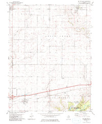
1979 Map of Weldon East
USGS Topo · Published 1980About this map
The Illinois Central Gulf railroad defines the transportation corridor of this central Illinois landscape, connecting the small agrarian hubs of Weldon, DeLand, and Cisco. These settlements are situated within the townships of Nixon, Goose Creek, and Willow Branch, where the land is carved by the winding paths of Goose Creek and Wildcat Creek. In the southeastern corner, the geography shifts toward the recreation and research grounds of Robert Allerton Park (University of Illinois), located along the banks of the Sangamon River.
Find a feature on this map
25 named features on this map. Tap any name to fly to it.
Don’t see what you’re looking for? This feature index may not catch every label — zoom into the map to look around manually.
Map Details
Editions of this 1979 Weldon East Map
This is the sole edition of this map. No revisions or reprints were ever made.
Other maps of this area

1929 · Decatur
USGS Topo · 1:62,500

1933 · Decatur
USGS Topo · 1:62,500

1937 · Monticello
USGS Topo · 1:48,000

1943 · Monticello
USGS Topo · 1:62,500

1955 · Bement
USGS Topo · 1:62,500

1957 · Maroa
USGS Topo · 1:62,500

1958 · Peoria
USGS Topo · 1:250,000

1958 · Decatur
USGS Topo · 1:250,000

1961 · Peoria
USGS Topo · 1:250,000

1961 · Decatur
USGS Topo · 1:250,000