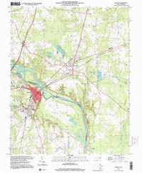
1997 Map of Weldon
USGS Topo · Published 2000About this map
The Roanoke River bisects this landscape, serving as the boundary between Halifax and Northampton Counties. The town of Weldon and adjacent South Weldon anchor the western bank, revealing a settlement pattern shaped by the river and transportation infrastructure. An Old Grade and RR Grade trace paths through the terrain, indicating the historical importance of rail corridors in this region. Local history is preserved in several community landmarks, including Cedarwood Cem and Oak Ridge Cem, alongside small rural congregations like Oak Grove Ch and Chapel Grove Ch. On the eastern bank, Garysburg sits amidst a landscape featuring numerous resource extraction sites like the Sandpit and various Gravel Pits. The significant river feature of Mush Island sits in the channel, while the surrounding area is drained by tributaries such as Chockoyotte Creek and Troublesome Field Creek.
Find a feature on this map
41 named features on this map. Tap any name to fly to it.
Don’t see what you’re looking for? This feature index may not catch every label — zoom into the map to look around manually.
Map Details
Editions of this 1997 Weldon Map
This is the sole edition of this map. No revisions or reprints were ever made.
Other maps of this area

1919 · Emporia
USGS Topo · 1:62,500

1919 · Arringdale
USGS Topo · 1:48,000

1920 · Arringdale
USGS Topo · 1:62,500

1942 · Arringdale
USGS Topo · 1:62,500

1942 · Emporia
USGS Topo · 1:62,500

1953 · Norfolk
USGS Topo · 1:250,000

1963 · Skippers
USGS Topo · 1:24,000

1963 · Barley
USGS Topo · 1:24,000
1966 · Claresville
USGS Topo · 1:24,000

1974 · Halifax
USGS Topo · 1:24,000