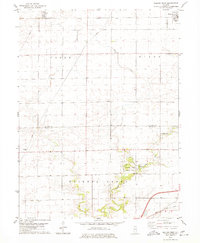
1979 Map of Weldon West
USGS Topo · Published 1980About this map
Weldon and Lane anchor this late 1970s survey of the central Illinois agricultural landscape. The region is defined by the sweeping course of Friends Creek, which flows southwest toward the Friends Creek County Park. This area preserves a more wooded, topographically varied environment compared to the surrounding gridded farmland. The Illinois Central Gulf railroad cuts through the terrain, serving as a primary corridor for the transport of local commodities and connecting these rural communities.
Find a feature on this map
12 named features on this map. Tap any name to fly to it.
Don’t see what you’re looking for? This feature index may not catch every label — zoom into the map to look around manually.
Map Details
Editions of this 1979 Weldon West Map
This is the sole edition of this map. No revisions or reprints were ever made.
Other maps of this area

1929 · Decatur
USGS Topo · 1:62,500

1933 · Decatur
USGS Topo · 1:62,500

1937 · Monticello
USGS Topo · 1:48,000

1943 · Monticello
USGS Topo · 1:62,500

1955 · Bement
USGS Topo · 1:62,500

1957 · Maroa
USGS Topo · 1:62,500

1958 · Peoria
USGS Topo · 1:250,000

1958 · Decatur
USGS Topo · 1:250,000

1961 · Peoria
USGS Topo · 1:250,000

1961 · Decatur
USGS Topo · 1:250,000