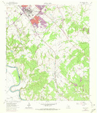
1961 Map of Wellborn
USGS Topo · Published 1973About this map
Texas A & M University serves as the focal point of this early 1960s study, documenting the campus and surrounding community during a period of significant growth. The map illustrates the university infrastructure in detail, including Kyle Field, the Rodeo Ground, and various academic buildings near New Main Dr and Bizzell St. Extensions shown in purple reflect revisions made in the early 1970s, tracing the expanding corporate boundaries of Bryan and College Station as they move toward the southwest.
Find a feature on this map
55 named features on this map. Tap any name to fly to it.
Don’t see what you’re looking for? This feature index may not catch every label — zoom into the map to look around manually.
Map Details
Editions of this 1961 Wellborn Map
4 editions found

Other maps of this area

1913 · Millican
USGS Topo · 1:31,680

1914 · Gay Hill
USGS Topo · 1:62,500

1914 · Navasota
USGS Topo · 1:62,500

1954 · Austin
USGS Topo · 1:250,000

1956 · Bryan
USGS Topo · 1:62,500

1956 · Carlos
USGS Topo · 1:62,500

1959 · Millican
USGS Topo · 1:24,000

1959 · Clay
USGS Topo · 1:24,000

1959 · Reliance
USGS Topo · 1:24,000

1959 · Ferguson Crossing
USGS Topo · 1:24,000