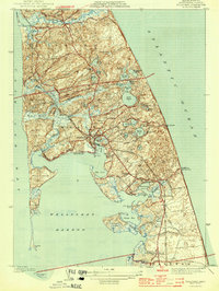
1944 Map of Wellfleet
USGS Topo · Published 1944About this map
Wellfleet and its neighbors in Truro are captured here as they appeared during the early 1940s, showing a landscape defined by glacial ponds and a complex maritime geography. The outer Cape Cod coastline reveals the transition from the sheltered waters of The Cove and Drummer Cove to the exposed eastern shore, where the Cahoon Hollow L S S life-saving station stands watch. Inland, the terrain is pocketed with numerous freshwater bodies like Gull Pond, Long Pond, and Slough Pond, reflecting the unique hydrology of the peninsula.
Find a feature on this map
72 named features on this map. Tap any name to fly to it.
Don’t see what you’re looking for? This feature index may not catch every label — zoom into the map to look around manually.
Map Details
Editions of this 1944 Wellfleet Map
5 editions found
Other maps of this area

1887 · Wellfleet
USGS Topo · 1:62,500

1887 · Provincetown
USGS Topo · 1:62,500

1889 · Provincetown
USGS Topo · 1:62,500

1889 · Wellfleet
USGS Topo · 1:62,500

1893 · Wellfleet
USGS Topo · 1:62,500

1898 · Provincetown
USGS Topo · 1:62,500

1942 · Cape Cod Bay
USGS Topo · 1:125,000

1942 · Nauset
USGS Topo · 1:125,000

1944 · Orleans
USGS Topo · 1:31,680

1944 · Wellfleet
USGS Topo · 1:31,680