
1985 Map of Wellington
USGS Topo · Published 1985About this map
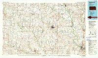
The Old Indian Treaty Boundary slices diagonally across this Kansas landscape, a visible reminder of 19th-century land divisions that predated the grid of the mid-1980s. Centered on Wellington, the county seat of Sumner County, the map captures a mature rail-and-river network where the Atchison Topeka and Santa Fe and Missouri Pacific lines converge. Small agricultural centers like Caldwell, Argonia, and Belle Plaine punctuate the plains, linked by the Kansas Turnpike and numerous local thoroughfares. The drainage of the Chikaskia River and Ninnescah River southward toward the Arkansas River defines the terrain, which is dotted with community landmarks like Prairie Lawn Cem and Wellington Lake City Park. These features reflect a region deeply rooted in both its pioneer past and its mid-century role as a logistical hub for the southern Kansas wheat belt.
Find a feature on this map
81 named features on this map. Tap any name to fly to it.
Don’t see what you’re looking for? This feature index may not catch every label — zoom into the map to look around manually.
Map Details
Editions of this 1985 Wellington Map
2 editions found
Other maps of this area

1888 · Eldorado
USGS Topo · 1:125,000

1889 · Burden
USGS Topo · 1:125,000

1889 · Anthony
USGS Topo · 1:125,000

1889 · Cheney
USGS Topo · 1:125,000

1889 · Wichita
USGS Topo · 1:125,000

1889 · Caldwell
USGS Topo · 1:125,000

1890 · Wellington
USGS Topo · 1:125,000

1891 · Cheney
USGS Topo · 1:125,000

1891 · Anthony
USGS Topo · 1:125,000

1892 · Kingman
USGS Topo · 1:125,000