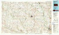
1985 Map of Wellington
USGS Topo · Published 1990About this map
Wellington serves as a central hub for the agricultural and rail landscape of south-central Kansas in the mid-1980s. This survey illustrates a region defined by its river systems and the heavy presence of the Atchison Topeka and Santa Fe and Missouri Pacific railroads, which facilitated the growth of smaller grain-loading towns like Argonia, Caldwell, and South Haven. To the east, the Arkansas River and Ninnescah River converge, shaping the placement of settlements like Oxford and Mulvane. A rare historical artifact appears in the northeast: the Old Indian Treaty Boundary, which cuts diagonally across the township grids of Richland and Rockford. The map also captures several municipal infrastructure points, including Wellington Lake City Park and the Wellington Municipal Airport, alongside numerous smaller agricultural communities such as Hunnewell and Bluff City near the southern border.
Find a feature on this map
127 named features on this map. Tap any name to fly to it.
Don’t see what you’re looking for? This feature index may not catch every label — zoom into the map to look around manually.
Map Details
Editions of this 1985 Wellington Map
2 editions found
Other maps of this area

1888 · Eldorado
USGS Topo · 1:125,000

1889 · Burden
USGS Topo · 1:125,000

1889 · Anthony
USGS Topo · 1:125,000

1889 · Cheney
USGS Topo · 1:125,000

1889 · Wichita
USGS Topo · 1:125,000

1889 · Caldwell
USGS Topo · 1:125,000

1890 · Wellington
USGS Topo · 1:125,000

1891 · Cheney
USGS Topo · 1:125,000

1891 · Anthony
USGS Topo · 1:125,000

1892 · Kingman
USGS Topo · 1:125,000