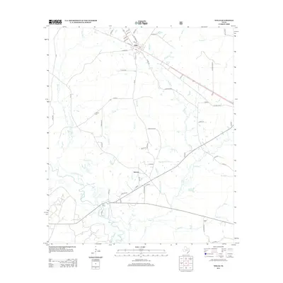
2013 Map of Wells
USGS Topo · Published 2013About this map
Wells serves as the primary hub in this portion of Cherokee County, where a grid of local streets like E 3rd St and May St meet near the diagonal path of the regional highway. The landscape south of the town is defined by a dense network of tributaries including Sapulpa Cr, Bodan Cr, and Durham Cr, which eventually feed into the Neches River along the southwestern corner. These waterways create a complex drainage pattern through the lowlands, interspersed with small settlements such as Redtown. Genealogy and local history researchers will find the locations of established burial grounds, including Simpson Cem north of Sapulpa Cr and Rowan Cem near the banks of Rowan Cr. The mapping of small creek branches like Tackleg Br, Wise Br, and McAdam Spring Br provides a clear view of the rural drainage and property divisions in this East Texas timber and creek-bottom country.
Find a feature on this map
68 named features on this map. Tap any name to fly to it.
Don’t see what you’re looking for? This feature index may not catch every label — zoom into the map to look around manually.
Map Details
Editions of this 2013 Wells Map
This is the sole edition of this map. No revisions or reprints were ever made.
Other maps of this area

1946 · Alto
USGS Topo · 1:62,500

1949 · Clawson
USGS Topo · 1:24,000

1949 · Keltys
USGS Topo · 1:24,000

1950 · Keltys
USGS Topo · 1:24,000

1950 · Clawson
USGS Topo · 1:24,000

1950 · Kennard NE
USGS Topo · 1:24,000

1950 · Centralia
USGS Topo · 1:24,000

1951 · Wells
USGS Topo · 1:24,000

1951 · Wells SW
USGS Topo · 1:24,000

1951 · Centralia
USGS Topo · 1:24,000