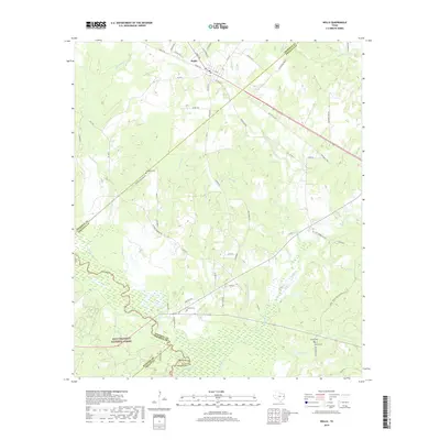
2019 Map of Wells
USGS Topo · Published 2019About this map
The town of Wells serves as the primary hub in this East Texas landscape, situated at the junction of the Old Wells Hwy and several rural county roads. The southern portion of the map is dominated by the dense woodlands of the Davy Crockett National Forest, where the Neches River defines the winding boundary between Cherokee, Angelina, Houston, and Trinity counties. This waterway, including its Old Channel, is fed by a network of drainage systems like Sapulpa Cr, Devils Bayou, and Red Bayou. For genealogists and local historians, several rural burial sites are documented across the terrain, including Simpson Cem to the west, Sandlot Cem near the forest boundary, and Rowan Cem in the southeast. The survey highlights the transition from the structured street grid of Wells to the irregular patterns of creek branches and spring-fed streams like McAdam Spring Br and Tackleg Br.
Find a feature on this map
72 named features on this map. Tap any name to fly to it.
Don’t see what you’re looking for? This feature index may not catch every label — zoom into the map to look around manually.
Map Details
Editions of this 2019 Wells Map
This is the sole edition of this map. No revisions or reprints were ever made.
Other maps of this area

1946 · Alto
USGS Topo · 1:62,500

1949 · Clawson
USGS Topo · 1:24,000

1949 · Keltys
USGS Topo · 1:24,000

1950 · Keltys
USGS Topo · 1:24,000

1950 · Clawson
USGS Topo · 1:24,000

1950 · Kennard NE
USGS Topo · 1:24,000

1950 · Centralia
USGS Topo · 1:24,000

1951 · Wells
USGS Topo · 1:24,000

1951 · Wells SW
USGS Topo · 1:24,000

1951 · Centralia
USGS Topo · 1:24,000