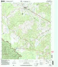
2004 Map of Wells
USGS Topo · Published 2006About this map
The town of Wells sits at the northern edge of this East Texas survey, where the corporate boundary meets the intersection of regional transit lines. Moving south, the landscape transitions into the heavily wooded stretches of the Davy Crockett National Forest, defined by a dense network of watercourses including Sapulpa and Bodan Creek. The map documents a rural social geography anchored by family and community landmarks such as Simpson Cem, Sandlot Cem, and the Bodan Ch Cem. In the southern reaches, the Neches River forms a significant natural border near Redtown, winding past Dry Lake at the meeting point of Cherokee, Angelina, Houston, and Trinity counties. This 2004 revision provides a clear record of these long-established settlements and forest boundaries as they stood at the start of the 21st century.
Find a feature on this map
25 named features on this map. Tap any name to fly to it.
Don’t see what you’re looking for? This feature index may not catch every label — zoom into the map to look around manually.
Map Details
Editions of this 2004 Wells Map
This is the sole edition of this map. No revisions or reprints were ever made.
Other maps of this area

1946 · Alto
USGS Topo · 1:62,500

1949 · Clawson
USGS Topo · 1:24,000

1949 · Keltys
USGS Topo · 1:24,000

1950 · Keltys
USGS Topo · 1:24,000

1950 · Clawson
USGS Topo · 1:24,000

1950 · Kennard NE
USGS Topo · 1:24,000

1950 · Centralia
USGS Topo · 1:24,000

1951 · Wells
USGS Topo · 1:24,000

1951 · Wells SW
USGS Topo · 1:24,000

1951 · Centralia
USGS Topo · 1:24,000