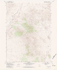
1968 Map of Wells Peak
USGS Topo · Published 1983About this map
The Windermere Hills dominate this high-desert landscape in northeastern Nevada, anchored by the prominent Wells Peak. This late-1960s survey records a network of vital water sources essential for survival and livestock in this arid environment, ranging from Town Cr Spring in the northwest to Summit Springs and Cricket Spring further north. These natural seeps are complemented by man-made infrastructure like Wrights Well, Ralphs Well, and a simple Well located near the mountainside.
Find a feature on this map
17 named features on this map. Tap any name to fly to it.
Don’t see what you’re looking for? This feature index may not catch every label — zoom into the map to look around manually.
Map Details
Editions of this 1968 Wells Peak Map
2 editions found
Other maps of this area

1955 · Wells
USGS Topo · 1:250,000

1958 · Wells
USGS Topo · 1:250,000

1961 · Wells
USGS Topo · 1:250,000

1968 · Moor Summit
USGS Topo · 1:24,000

1968 · Holborn
USGS Topo · 1:24,000

1968 · Wells
USGS Topo · 1:24,000

1968 · Melandco
USGS Topo · 1:24,000
1968 · Pequop Summit SW
USGS Topo · 1:24,000

1968 · Wells Peak
USGS Topo · 1:24,000

1968 · Summer Camp
USGS Topo · 1:24,000