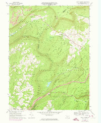
1968 Map of Wells Tannery
USGS Topo · Published 1974About this map
Wells Tannery sits at the intersection of several mountain ridges near the border of Bedford and Fulton counties, serving as a focal point for this rural Appalachian landscape. The terrain is defined by the massive slopes of Kimber Mountain, Rays Hill, and Sideling Hill, which channel development into valleys like Sherman Valley and Brush Creek Valley. Evidence of the area’s resource-based economy is visible in the north with a Strip Mine and the dense woodland of Buchanan State Forest. The map documents a network of named trails and roads such as Dug Road and Bark Road that connect isolated landmarks like Shortys Place and Old Mtn House. Religious and community life is reflected in several remote country churches, including Sherman Valley Ch and Mountain Chapel, highlighting the self-contained nature of these mountain gap settlements during the late 1960s.
Find a feature on this map
55 named features on this map. Tap any name to fly to it.
Don’t see what you’re looking for? This feature index may not catch every label — zoom into the map to look around manually.
Map Details
Editions of this 1968 Wells Tannery Map
4 editions found
Other maps of this area

1900 · Everett
USGS Topo · 1:62,500

1902 · Everett
USGS Topo · 1:62,500

1925 · Needmore
USGS Topo · 1:48,000

1927 · Clearville
USGS Topo · 1:48,000

1930 · Broad Top
USGS Topo · 1:62,500

1931 · Clearville
USGS Topo · 1:62,500

1933 · Broad Top
USGS Topo · 1:62,500

1935 · Needmore
USGS Topo · 1:62,500

1939 · Needmore
USGS Topo · 1:62,500

1944 · Clearville
USGS Topo · 1:62,500
Featured Places
- Valley-Hi, PA
- Shortys Place, Brush Creek Township
- East Providence Township, PA
- Graceville, East Providence Township
- Wells Tannery, Wells Township