
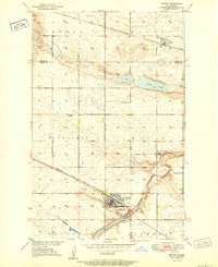
1950 Map of Wellsburg
USGS Topo · Published 1950About this map
The Sheyenne River carves a deep, winding valley through the center of this Central North Dakota landscape, creating a stark contrast to the surrounding glaciated plains. In the mid-20th century, the Great Northern railroad served as the primary industrial lifeline for the small settlement of Wellsburg, positioned where the tracks run parallel to the county line. The map captures a transition in rural education, documenting several numbered country schools including Odessa Sch No 1, School No 3, and South Fram Sch scattered across the townships of Hagel and Fram. A notable landmark, Butte De Morale, rises prominently above the western plains, while the East Fork drains the northeast corner, illustrating the complex water patterns that dictated early farmstead placement in Wells County.
Find a feature on this map
18 named features on this map. Tap any name to fly to it.
Don’t see what you’re looking for? This feature index may not catch every label — zoom into the map to look around manually.
Map Details
Editions of this 1950 Wellsburg Map
This is the sole edition of this map. No revisions or reprints were ever made.
Other maps of this area

1941 · Selz
USGS Topo · 1:62,500

1943 · Maddock
USGS Topo · 1:62,500

1945 · Maddock
USGS Topo · 1:62,500

1945 · Manfred
USGS Topo · 1:62,500

1948 · Fessenden
USGS Topo · 1:62,500

1948 · Manfred
USGS Topo · 1:62,500

1949 · Fessenden West
USGS Topo · 1:24,000

1950 · Manfred NW
USGS Topo · 1:24,000

1950 · Manfred
USGS Topo · 1:24,000
1951 · Harvey
USGS Topo · 1:24,000