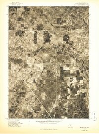
1976 Map of Wellston NE
USGS Topo · Published 1976About this map
The Pine River meanders sharply across the center of this 1976 orthophotograph, providing a clear visual record of the river's complex oxbows and floodplain within Wexford County. Produced by the Geological Survey, this aerial-based study uses photography captured in May of 1976 to reveal the intricate land use patterns of the era. The contrast between dense woodlots and rectangular agricultural clearings is immediately apparent, showing how the local landscape was managed and divided during the mid-1970s. For researchers and property historians, the map's photographic nature preserves exact details of forest cover, rural roads, and field boundaries that standard topographic drawings often simplify. It serves as a precise baseline for understanding the environmental and structural state of this Michigan landscape before later decades of growth and reforestation changed the local footprint.
Find a feature on this map
1 named feature on this map. Tap any name to fly to it.
Don’t see what you’re looking for? This feature index may not catch every label — zoom into the map to look around manually.
Map Details
Editions of this 1976 Wellston NE Map
This is the sole edition of this map. No revisions or reprints were ever made.
Other maps of this area

1933 · Peacock SE
USGS Topo · 1:31,680

1933 · Peacock SW
USGS Topo · 1:31,680

1933 · Peacock NE
USGS Topo · 1:31,680

1933 · Luther SW
USGS Topo · 1:31,680

1933 · Luther NW
USGS Topo · 1:31,680

1933 · Peacock NW
USGS Topo · 1:31,680

1954 · Traverse City
USGS Topo · 1:250,000

1956 · Mesick
USGS Topo · 1:62,500

1957 · Copemish
USGS Topo · 1:62,500

1957 · Luther
USGS Topo · 1:62,500
Featured Places
- Eden Township, MI
- Newkirk Township, MI
- Norman Township, MI
- South Branch Township, MI
- Garletts Corner, MI